Transportation and Transit Plan 10 – Metrotown to Cap U B-Line

This week, I’ve been going to cover some of the major projects that are planned to be implemented in 5-10 years after a Yes vote to the upcoming transit ballot. If Metro Vancouver residents vote Yes to the 0.5% PST increase, then 2020-2025 will see some of the largest transportation projects ever in the history of our region.

There are more B-Line buses slated to start service between 2020 and 2025.

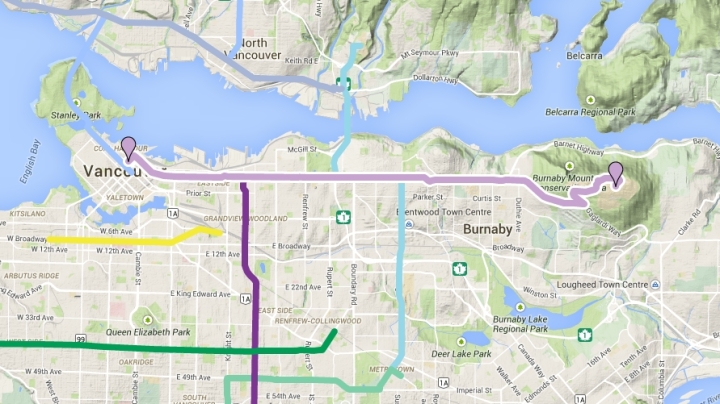
Metrotown to Capilano University B-Line

metrotown to capu bline map

This B-Line bus will run mostly along Willingdon Avenue in Burnaby. Currently, this route is serviced by the #130 bus that runs 9 buses every hour between Metrotown and Brentwood – the busiest section of this route. The buses alternate between ending the runs at Hastings and Willingdon or at Kootenay Loop in East Vancouver. In the morning and afternoon rush hours, a few of the buses go to North Vancouver and end at Phibbs Exchange or Capilano University. The #130 is also a milk run that stops at every single bus stop along the way.

Continue reading “Transportation and Transit Plan 10 – Metrotown to Cap U B-Line”

Transportation and Transit Plan 9 – Patullo Bridge Replacement

This week, I’m going to cover some of the major projects that are planned to be implemented in 5-10 years after a Yes vote to the upcoming transit ballot. If Metro Vancouver residents vote Yes to the 0.5% PST increase, then 2020-2025 will see some of the largest transportation projects ever in the history of our region.

Patullo Bridge Replacement

From background to foreground – SkyBridge, Patullo Bridge, and the swinging New Westminster Railroad Bridge

Continue reading “Transportation and Transit Plan 9 – Patullo Bridge Replacement”

Transportation and Transit Plan 8 – Surrey LRT

This week, I’m going to cover some of the major projects that are planned to be implemented in 5-10 years after a Yes vote to the upcoming transit ballot. If Metro Vancouver residents vote Yes to the 0.5% PST increase, then 2020-2025 will see some of the largest transportation projects ever in the history of our region.

Surrey LRT

Continue reading “Transportation and Transit Plan 8 – Surrey LRT”

Transportation and Transit Plan 7 – Third SeaBus

Here’s the first of the projects in my list that is not a B-Line. It’s an improved SeaBus service. This is project #7 my look at the Regional Transportation Investments that will transform Metro Vancouver as we know it.

SeaBus – increased frequency and a third ship

photo by Riley Huntley

The SeaBus is one of the most popular and iconic routes in the TransLink system. The SeaBus is a popular experience for tourists who want a different view of Downtown Vancouver by traversing to North Vancouver’s Lonsdale Quay. Lonsdale Quay is growing with some new condos in the area. The market at the Quay is also a popular draw for locals and tourists alike. The Quay is definitely a major transport hub with many major North Shore buses connecting the SeaBus to other places on the North Shore.

Continue reading “Transportation and Transit Plan 7 – Third SeaBus”

Transportation and Transit Plan 6 – 41st Avenue B-Line

Project #6 is another university bound B-Line in the Regional Transportation Investments that will transform Metro Vancouver as we know it.

41st Avenue B-Line (Joyce Station to University of British Columbia)

41st ave bline map

This route is of personal importance to me. I took a bus out to UBC during my uni days and endured many 1-hour bus rides along 41st Avenue. The 41st Avenue B-Line would be another express bus upgrade. This route is currently served by both #41 and #43 buses. The #43 is the current express bus that only runs during rush hour.  I would hope a new B-Line along 41st Avenue would bring all-day, frequent, limited-stop service to 41st Avenue.
Continue reading “Transportation and Transit Plan 6 – 41st Avenue B-Line”

Transportation and Transit Plan 5 – Hastings Street B-Line

This is project #5 in my project-by-project look at the Regional Transportation Investments that will transform Metro Vancouver as we know it. And yes, it’s another B-Line.

Hastings Street B-Line (Downtown to Simon Fraser University)

hastings bline map

The Hastings B-Line would be an upgrade of the current 135 SFU/Burrard Station express bus. The 135 is already a fairly frequent bus with limited stop service. The B-Line version would require just a bit of tweaking and some additional buses to make it even more frequent. Perhaps more frequent service throughout more of day would be part of the upgrade. Continue reading “Transportation and Transit Plan 5 – Hastings Street B-Line”

Transportation and Transit Plan 4 – Surrey Centre to Langley B-Line

Here’s the fourth post in my project-by-project look at the Regional Transportation Investments that will transform Metro Vancouver as we know it. It’s yet another B-Line that is south of the Fraser River.

Fraser Highway B-Line

surrey centre to langley bline map The proposed Fraser Highway B-Line from Surrey Centre to Langley Town Centre is a monster bus route. It travels a total of 16.6 km and goes through 3 different municipalities – Surrey, Langley, and Langley Township.  The B-Line is planned to start operation within the first 5 years of a YES vote.

Continue reading “Transportation and Transit Plan 4 – Surrey Centre to Langley B-Line”

Transportation and Transit Plan 3 – Scott Road Station/Newton Exchange B-Line

Here’s the third post in my project-by-project look at the Regional Transportation Investments that will transform Metro Vancouver as we know it.

Scott Road Station/Newton Exchange B-Line

north delta bline map
Scott Road Station to Newton Exchange B-Line (highlighted in blue with white outline)

Here’s a nod to better transit in North Delta. Delta is one of those municipalities that tends not to get transit. Why? Not that many people live in Delta. Most of the people that live in Delta live in North Delta that is right next to North Surrey.

Continue reading “Transportation and Transit Plan 3 – Scott Road Station/Newton Exchange B-Line”

Transportation and Transit Plan 2 – Richmond Centre/Metrotown B-Line

The Mayor’s Council has put forward a vision for Regional Transportation Investments for Metro Vancouver for the next 10 years. Some of these investments will happen within the next 5 years. Others will happen between 2020 and 2025. This all depends on those living in Metro Vancouver voting Yes in the upcoming mail-in referendum/plebiscite ballot.

Here’s the second post in my project-by-project look at the Regional Transportation Investments.

Richmond Centre/Metrotown B-Line

richmond-metrotown bline map

Continue reading “Transportation and Transit Plan 2 – Richmond Centre/Metrotown B-Line”