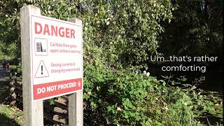
Cariboo Dam is on the eastern end of Burnaby Lake and controls the water levels in the lake and flow of water into the Brunette River. It’s a popular spot to visit in the Fall when salmon return to spawn. No luck in October on this visit. November is the best time to go check out the salmon in the fishway. Watch this metro minute … Continue reading 2021 10 11 – Cariboo Dam
It’s ready to roll. The first video hits the Net on October 14, 2021 @9:00pm. YouTube has this whole premiere video countdown. But if you are looking for the actual video, here it is. Tune in, like, subscribe, share, and hit the bell for notifications. Continue reading Premiere Video – October 14, 2021 @ 9:00pm PDT
In December, I had the good fortune of travelling to Phoenix for a work conference. My manager was really excited to tack on a Grand Canyon day trip (on our own dime) to our work weekend in Arizona.
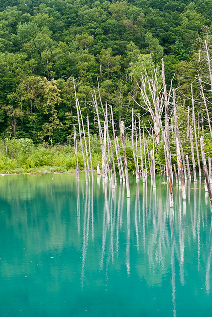
After being awed by the lavender fields of Farm Tomita, we were on our way again. However, I had no idea what our next stop was. I don’t remember ever receiving a travel itinerary. We were in the hands and at the whims of our two accompanying teachers from Hokkaido Japanese Language School. It turns out that our next stop on our highway coach field trip was to the Blue Pond, or Aoiike (青い池).
One of our shared house-mates had been talking about visiting the “pyramid” park. It sure sounded interesting to visit a park with pyramids. I wasn’t sure what to expect from a “pyramid” park. I envisioned some kitschy kids park with a large colourful pastel playground consisting of pyramids. Sure. Why not? So we had planned to go out there one afternoon after our language classes were done.
bicycles outside our share house
We had secured a couple bicycles from another shared house for our afternoon trip to the park. The park was apparently pretty far. With the bicycles ready to go, we set out for the “pyramid” park. However, we forgot to check what the name of the park was in Japanese. Oops.
So we rode out to the northeast of the city. Our house mate knew the general direction of the park, but he couldn’t quite remember exactly how far out the park was. We kept riding north past the freeway and we started to even pass farmland. We were out pretty far from the city limits.
Finally, though, we started to see a tall, pyramidal hill show up on the horizon. That was our destination. Now just where was the entrance exactly? I think we could have entered the park from the south side, but we ended up going to the north side. We locked up our bikes at the northwest entrance to the park.
I’ve been on Flickr since 2006. As my regular blog followers know, I love photography. I wish I had better equipment and a better eye. Both of which can be improved. One requires money. The other requires just a lot of practice. A better eye also comes about from immersing oneself in gorgeous photography. I wanted to share my latest Flickr crush with everyone. CoolbieRe … Continue reading Flickr Crush – CoolbieRe
There’s only one main highway to the west coast of Vancouver Island. That’s the Pacific Rim Highway. The highway is Highway #4 that branches off Highway #19 (Inland Island Highway) near Qualicum Beach. The first highly recommended stop along the way is the tiny town of Coombs. However, Coombs is probably home to one of the largest, international markets I have seen on Vancouver Island. … Continue reading Pacific Rim Highway – to Tofino and Ucluelet
Before I ever visited the Comox Valley, I had never heard of the Royston Wrecks. I had come across a small blurb in a visitor’s guide to Courtenay and Comox describing this collection of ship wrecks. Royston is a small town minutes south of Courtenay along the Old Island Highway. I would never think of stopping here, but I found a little road that leads … Continue reading The Royston Wrecks