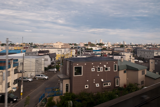
I was originally call this “Why I don’t like Mississauga.”  Sorry to those who live in Mississauga.  This is not a judgement of Mississauga as a whole.  It’s simply a judgement upon one part of Mississauga.  However, the pattern of what I found in one area of Mississauga seems to repeat itself around the city and in other similar cities across North America.  I’m just picking on Mississauga as my case study.

The parts of Mississauga that I often find myself in are the industrial/business park areas.  For work, I may be put up in a hotel close to the company office in Mississauga.  It’s easy for us to head over the office then.  However, I hate being at these “middle-of-nowhere” hotels with very little in terms of anything interesting in the neighbourhood.

My most recent trip to Mississauga saw myself and a coworker set up in a hotel just off the freeway.  We had dinner in the hotel because there was no other choice.  It was the only restaurant in walking distance.  We were not about to take a taxi or rent a car just to go get dinner.  Since there was no nearby competition for the restaurant, the prices were higher than expected.

After dinner, we decided to go for a walk around the hotel to see if there was anything nearby.  We walked out to the road and could only see a few buildings behind the black asphalt of road and parking lots and amongst green grass lawns.  There were some office towers nearby of some major banks surrounded by large parking lots.  We didn’t go very far, just across the street.

When we’re in a downtown area, at least we get to walk around after meals and explore the city.  There’s nothing to explore in these suburban business park areas.  Unless you have a car, you are not exploring anything.

Thankfully, the next night, the company took us downtown for dinner and just walking the few blocks from our drop off point to the restaurant was exciting on its own.  It helped that there was a road bike race in the St. Lawrence Market area.  That was absolutely fun to see for a short while, even though we had to run across the race track to get to our restaurant.

Suburban business parks – thumbs down.

Posted by: metrobabel | July 7, 2009

Canada blows post-oil economic opportunities

Canada blows post-oil economic opportunities >> Times Colonist, July 7, 2009.

This one of those articles that would have slipped off on the sidelines if it weren’t for the diligent folk at the Sightline Institute scouring the media for relevant news.

There was a time when politicians claimed Canada would become a world leader in clean, green technologies — that our educated workforce, abundant resources and entrepreneurial spirit, coupled with inspired government policy, would revitalize our economy and help save the planet.

Canada blowing another economic opportunity?  Not surprising.  I’ve grown up with the image of Canada being behind on everything.  We seem to like the status quo and not take the risks of being a leader.  Unfortunately for us, being a low on the risk scale means we also lose out on the great potential return.

Meanwhile, Canada has slipped to eighth place among G8 nations when it comes to tackling climate change, according to a recent report from the World Wildlife Fund. While Germany and England have reduced emissions in recent decades, Canada’s have increased 26 per cent since 1990.

“Canada is becoming increasingly isolated in clinging to the fossil economy while the rest of the world is moving on to a green economy,” says Keith Stewart of the WWF.

We’re the worst of the G8 nations!  Isn’t that sad?  We’re not a leader, but just a sideline watcher.  If Germany and England have not been severely hampered by their emission reductions, why would Canada?  Why are we different?  Are we so reliant on our resources that the effect of carbon reduction would reduce our economy to rubble?  Is Germany and England suffering economically because of their carbon reductions?  Probably not because we are all suffering globally because of the huge credit crunch.  Canada truly is a dinosaur right now.  Can we put Canada on display at Metrotown with the other dinosaurs?

And it isn’t only the Harper government. Liberal Leader Michael Ignatieff was in Alberta last week, proposing a pipeline to bring Alberta gas and oil east. He is already a vocal champion of the oilsands.

// maxlimit) // if too long…trim it!
field.value = field.value.substring(0, maxlimit);
// otherwise, update ‘characters left’ counter
else
{
var divLabel = document.getElementById(”divLabel”);
divLabel.innerHTML = maxlimit – field.value.length + ” characters remaining”;

}
}
// ]]>

The NDP, too, has lost any claim to leadership on the environment — partly because of its over-the-top opposition to a carbon tax (still the most elegantly simple remedy) and partly because it has been more concerned, of late, with preserving union jobs.

So it falls to the Green Party, the Bloc Québécois and some premiers to press for a green future.

Obviously it’s not a pretty environmental picture on the political landscape.  No wonder 10% of Canadians vote for the Green Party.  There’s not much choice out there when it comes to the environment; only a best of the worst scenario.

Posted by: metrobabel | July 7, 2009

The high cost of ‘free’ parking

The high cost of ‘free’ parking >> Vancouver Sun, July 7, 2009.

A very important article in the back of the Vancouver Sun’s Tuesday edition.  Usually you find important transport information on Friday’s when nobody is reading, but this one is a guest opinion-editorial from the looks of it.

Municipal regulations requiring urban developments to provide on-site parking seem innocuous and receive little attention in public policy discussions, but they do in fact have serious consequences.

They stimulate urban sprawl, encourage excessive use of cars, create inequitable social outcomes, reduce housing affordability, and suppress economic development. Wiping parking regulations from municipal planning codes across Canada is arguably the most urgent policy reform Canada’s municipalities can make.

That’s a pretty strong thesis, in terms of what it is proposing.  However, if you sit down and think about it, it is very true that parking can induce car travel.  Perhaps, parking can induce more travel than even a freeways and bridges.  If you don’t have anywhere to park your car when you arrive at your destination, then how likely are you to drive?

The cost of parking can be substantial. The Toronto Parking Authority estimated that the cost of providing a single parking space could be up to $40,000.

That’s not a surprising figure.  Condo developers have been asking Vancouver city hall to relax their parking regulations for many of the new condo high rise developments in downtown.  Developers know that downtown has enough amenities, walkability, and public transit that they can get away with less parking spots in new projects.

I know my friends who bought condos in downtown Toronto had to also buy their parking spots separately.  Some of them use the spots as mortgage helpers.  If you don’t have a spot and need one, then you can rent a spot or put your bid in for a spot when a parking spot becomes free.

Unlike many deregulation initiatives, the removal of minimum-parking regulations does not need to be sudden or disruptive. If parking regulations were removed today, Canada’s urban areas would adapt slowly over years with new developments having only small impacts on the demand for parking. Instead of regulating the supply of parking, municipalities would need to shift focus to managing demand for parking, which they can do through the use of time-limits and ultimately prices.

I think we’re already seeing this sort of deregulation in Toronto and Vancouver.  Especially since developers are asking for less parking so that units can become more affordable. Toronto has parking that is not packaged in with condos automatically.  Vancouver is starting to have new developments with units that have access to a car share (e.g. the Capitol Residences).

One good example of less parking, or no parking in this case, is The Hub at Commercial Drive/Broadway SkyTrain stations.  There are a few offices, restaurants, and large pharmacy, but no parking at all.  It’s attached to the SkyTrain stations, so it makes sense not to have parking.  The City of Vancouver made a special exemption for this site, if I remember correctly.

A really sad example of minimal parking regulations is actually across the street from The Hub.  It’s the CIBC on the southeast corner of Broadway and Commercial.  I learned about this case at a talk a few years ago where someone from Via Architecture was speaking.  Via wanted to develop that site with no parking spots.  That makes sense since it is also right beside the SkyTrain station.  I believe the City of Vancouver was willing to make an exemption for this site as well.  However, CIBC has a policy of minimum parking spots for its patrons.  I believe the number was 3 minimum parking spots.  So it wasn’t municipal parking regulations getting in the way here.  It was the bank.  If we look at that intersection, we would realistically say that most of the bank’s patrons walk to it either solely by foot or from transit.  The southeast corner of Broadway and Commercial is still prime for redevelopment as some sort of mixed use site.  Having only a bank and its few parking spots occupying that space seems like an awful waste.

Posted by: metrobabel | July 6, 2009

Canada Line preview – time lapse video

I’m surprised I didn’t come across this video earlier.  The video is from May 2009 and is a time-lapse (albeit in reverse) of a run along the Canada Line from Waterfront Station all the way to the airport.   The video actually stops short of YVR station, which is a shame.  However, it gives you an idea of how the line will feel like if you were riding at the front of the train.

Posted by: metrobabel | July 2, 2009

Kingsway – building footprint map

Kingsway: Building footprint figure-ground >> re:place Magazine.

Kingsway Figure-Ground - by Erick Villagomez

Kingsway Figure-Ground - by Erick Villagomez

I must say I really love Erick Villagomez’s cartography work.  He creates such interesting maps of the urban environment.  These are maps that you wouldn’t normally see.  He creates maps that make you pause and look at the city at a different way.  I, for one, am very happy he lives and works in Vancouver.  That way I get to see some interesting work about the place I love and live in.

Read his piece from re:place magazine for a full explanation of what you are looking at.

Posted by: metrobabel | July 1, 2009

My suggestions to TransLink on raising funds

TransLink has a site up to give them some feedback on how to direct the growth of the regional transportation system.  You can participate at bepartoftheplan.ca.  Here’s what I wrote in my comment area of the survey.  You can tell that I take a lot of my cues with my experience in Hong Kong.  Thus far in my transit experience, Hong Kong has the best multimodal transit system.  So here’s my two-cents and more to the folks at TransLink.

TransLink can form partnerships with corporations where frequent use of the future SmartCard come with rewards.  The reward could be a small gift from a corporation or a small discount from a retailer.

Hong Kong’s MTR has promotions similar to McDonald’s Happy Meal gifts.  It rewards those who are frequent travellers.  For example, if someone takes 10 rides in a set one week period, then they will qualify for a reward.  This commercial promotion will hopefully bring in some more revenue to TransLink.

Also, many tourist transit passes come with tourist coupons.  The same could be promoted within TransLink and help encourage tourists to take transit to major destinations.

Another possible revenue source is selling the SkyTrain and Coast Mountain Bus image to major model companies like Corgi.  The sales of these models would see a portion of the profit come back to TransLink.  This is a creative way to brand and market TransLinks many transit services.

Posted by: metrobabel | July 1, 2009

How will we pay for the transit system we NEED?

A matter of LIVABILITY >> Vancouver Sun, June 19, 2009

[Like I said on a previous post, I'm totally behind.  This has been sitting in my drafts for a couple weeks.]

An apt title in the Vancouver Sun for how are we going to live in the future.  That will be decided by our transportation plan in the next couple of decades.  We need a lot of transit if we are going to change we move around this city.

I purposely live within walking distance to a SkyTrain so I don’t have to drive everywhere.  Obviously, everyone doesn’t want to live as close to the train as I do, but that’s my choice.  If we have more choice, especially buses, maybe more people will make that choice.

A frequent bus network that requires a bus every 15 minutes is not frequent enough for me, but it is a huge improvement to a bus every 30 or 60 minutes.  That’s already double the service.

However, we have to pay for it somehow.  There is only one taxpayer.  Most of our taxes do not go to our cities. They go up to the provincial and federal level.  My property tax is piggly compared to what I give to the upper levels of government.  The provincial and federal governments have already taken our cash and they should siphon it back into a decaying infrastructure, including our transit system.

I’ve heard it over and over again that TransLink hasn’t the funds to do their work.  Even maintaining the status quo is costly.  The province, through two different political administrations, has always handcuffed TransLink since its inception.  It has the mandate to build, improve, maintain and run our road and transit system in Metro Vancouver; however, it has never been given the full funds to carry out its mandate.  Now, it has to go through silly exercises in consulting the public on how best to take money from them.

TransLink has gone so far as to devise a board game, called It’s Your Move, for use by Metro Vancouver residents. The game allows people like Anderson to set their priorities and then choose how to pay for them — for example, through increased property and gas taxes or a vehicle levy.

Each option has a point value attached, so that at the end of the game, players can see if they can afford their transit priorities using their revenue-raising choices.

According to statistics from those already playing online, most people believe TransLink needs another $450 million annually and, if they must support some form of increased taxation, a differentiated vehicle levy — one that has a higher fee for gas-guzzlers like SUVs– tops the list, Hardie said.

Raising property taxes — which is opposed by Metro’s 21 mayors — appears to be out of the question for most people.

Hmm… maybe TransLink can make some real coin by creating a blockbuster transit board game that they could sell.  I’d buy it.  I’m already a big fan of the Ticket to Ride board game series.  However, to make the game a competition, they’ll need to introduce rival transit companies to compete with TransLink.

Even with my cynicism about such exercises, they do sometimes flesh out some interesting results.  Most participants are in favour of the vehicle levy that was shouted out many years ago.  I still think the vehicle levy is a good idea.  Of course, my family owns a small car so we have less at stake here.  However, up to $275 is pennies compared to what a SUV driver already paid for when they purchased the vehicle.

My other comment about cars and levies is that we have plenty of room to raise prices on car related things like tolls and levies.  Sure, nobody likes to hear about an increase in their cost of living.  However, we in North America are very forunate (or unfortunate depending how you look at it) to have car ownership within easy reach.  Many countries charge a premium for owning a car.  Car ownership in many places are at least double what it costs here.

Imagine buying your lowly, but noble, Toyota Corolla for $40,000.  Yikes!  Ah.  But it makes you think twice about owning a car, doesn’t it?  The only problem is, we need to redesign our cities so that we can get around with a car.  The mantra again is that land use and transportation go hand-in-hand.  A concept that many city planners and powers-that-be still don’t seem to grasp.

Posted by: metrobabel | June 30, 2009

Biking Richmond breezy, Knight St Bridge wheezy

On one of my days off, I needed to be in Richmond for the morning, but without a car.  I have a monthly pass for Vancouver, but I have to pay extra when I’m in Richmond.  So I decided that I would get around Richmond by my bike instead of just bussing around.

I rode my bike to the bus stop and then just put my bike on the front end bike rack on the bus into Richmond.  It was the 491 One Road bus.  I liked it because it got me closer to where I was going than the 98 B-Line.  When the Canada Line opens, I’m not sure if the One Road bus will still come into Vancouver.  I suspect it will be cut in favour of funnelling all passengers on to the new line.

After my appointment, I decided to head to the Richmond Olympic Oval (ROO) on the banks of the middle arm of the Fraser River.  It was a beautiful morning and the sun was shining brightly.  I don’t think had enough sleep, so I parked my bike and made myself comfy on one of the new benches just behind the ROO.  The sun was wonderfully warm.  After a brief nap, I was hungry and went on search for some late breakfast.

I cycled along the dykes all the way to Cambie Road.  I went by Aberdeen Centre, but discovered that it wasn’t open yet.  I cycled down to Alexandra Road and found a Hong Kong style cafe where I grabbed a $6 breakfast combo complete with eggs, sausage, macaroni & ham, and a drink. You can’t beat that deal.

Richmond Olympic Oval to Aberdeen Centre (blue)

Richmond Olympic Oval to Aberdeen Centre (blue)

After a quick breakfast, I decided to go back to Aberdeen Centre. Beside the cafe, I discovered a little path between two of the shopping complexes that connects Alexandra Road to Leslie and Brown Roads.  Those roads were much nicer to bike down than Hazelbridge because they were residential streets with little traffic.  Whereas Hazelbridge is a mess of tangled traffic trying to get in and out of all the driveways to the little shopping malls.  I tried Hazelbridge earlier and it was quite hairy.  I was always checking for right turners and all the driveways meant a car could be coming out of a parking lot at anytime.  Brown Road, which runs parallel to Hazelbridge was much nicer to ride.

A loop from Aberdeen Centre to Alexandra Road and back (green)

A loop from Aberdeen Centre to Alexandra Road and back (green)

After a little while at Aberdeen Centre, I decided to make my way home.  I didn’t really feel like paying extra to cross back across the Fraser, so I decided to bike it.  I tried out the new bike lanes along No. 3 Road underneath the Canada Line guideway.  The lane was okay in its current state.  It’s not totally finished and there is a lot of dust and debris on the lane at the moment.  The City of Richmond has not finished everything yet, obviously.  One nice thing is that the bike lane is slightly elevated compared to roadway.  What I don’t like is that the lane is right beside the car traffic lane.  I’d rather have been an extra lane beside the sidewalk.  It would have been less freaky.  However, I managed to keep up with traffic because of all the lights along No. 3 Road.

I cycled up past the River Rock casino towards the new North Arm Bridge that will carry the new Canada Line trains.  I was hoping they had already opened the bike and pedestrian portion of the bridge, but the fence was locked shut.  From what I saw, the bike and pedestrian portion are fairly wide and should accommodate both bikes and walkers fairly well.  You can actually see the onramp on the Google Maps satellite shot below.  Since the North Arm Bridge wasn’t open yet, I decided to make my way to the Knight Street Bridge.

North Arm Bridge pedestrian/bike onramp (red marker)

North Arm Bridge pedestrian/bike onramp (red marker)

I followed River Road most of the way.  I was hoping to follow the dykes along the Fraser River all the way to Knight Street. In West Richmond, the dykes have paths along them, but in this part of Richmond, there is no dedicated path and people cannot access the riverfront at all points.  So I had to stay on River Road.  Fortunately, it wasn’t too busy along the road, although there were a couple of semis from time to time.

I did manage to pass by the Richmond Night Market location and saw them setting up for the Victoria Day long weekend opening.  As I passed by, I was wishing there was a better way to reach the market than by driving.  It seems like everyone drives to the Night Market.  I think the market worked better when it was in the huge parking lot at Lansdowne Mall.  Rent is probably cheaper in their current location, though.

Along River Road to Knight & Marine (red)

Along River Road to Knight & Marine (red)

Getting onto the Knight Street bridge was a challenge.  I made the mistake of going under the bridgespan first and trying to find a way onto the bridge from the east side of Knight Street.  I went in a huge loop before I could get onto the bridge itself.  Cyclists have to take the sidewalk on the bridge and you can tell that the sidewalk was designed to accommodate either one pedestrian or one cyclist at a time.  It was very narrow.

Not only was the path narrow, but it was extremely dusty.  The dust was often blown up into my face by the traffic on bridge.  The large semis were the worst.  You could feel the rush of air as they passed by.  And here I was just working hard to make it to the crest of the bridge.  When you get to Mitchell Island, you have to cross one offramp and one onramp to keep going.  That wasn’t too bad.  It was at the offramp for Marine Drive where it was crazy.  Cars coming off the Knight Street Bridge at speeds ranging from 60-80 km/h.  I just stood and waited for a break in the traffic.  A semi was nice enough to just slow to a crawl, block traffic for me, and let me across the offramp.

By the time I was across Marine Drive, I was in no mood to try and climb up the hill.  I just rolled my bicycle to the #22 bus stop underneath the bridgespan.  I took the bus up to a higher elevation and then cycled my way home. Overall, I was happy with the distance I had cycled.  I had cycled over 13 kms.  Richmond was nice and flat and easy to ride, but the ride across the Knight Street Bridge is not an experience that I want to repeat.

Posted by: metrobabel | June 30, 2009

Shifting Gears II – Walking « Stephen Rees’s blog

Shifting Gears II – Walking >> Stephen Rees’s Blog

[I am totally behind in everything these days.  I'll conveniently blame it on summer :) ]

It looks like our good friend Stephen was at one of those great free public lectures that are held downtown.  This one was at UBC Robson Square.

I especially like this graph about the health costs of different transport interventions.  Note that anything involving the status quo with personal vehicle numbers has a huge swath of red.  Reducing travel demand and improving public transit, walking, and cycling interventions make the biggest difference.

Stephen takes the example of the changes in Birmingham to point out the real life effects of less travel demand and more non-automobile infrastructure.

Birmingham, England

Birmingham, England - photo from Stephen Rees

Birmingham – Britain’s second largest city which in the sixties had built a huge inner ring road with multiple pedestrian subways that essentially killed the City centre as a shopping area: the area has now been almost completely overhauled with the removal of both ring road and subways. As a result it has moved from 13th to 3rd place in the national hierarchy of  retail destinations.

What really surprises me is that they removed the subways.  Now, subways could mean pedestrian underpasses like they do in Hong Kong.  Hong Kong was a British colony, so I have a suspicion that subway here means an underpass, not a transit system.  However, according to the talk, Birmingham’s city centre has become a bustling core with less cars.  Vancouver’s downtown has definitely seen a pedestrian rennaissance with more people living downtown and no huge changes in road access.  Our downtown is more active than it’s ever been with a smaller percentage of cars going downtown.

My reaction to this lecture was that I had heard nearly everything in it before. This is not a criticism of Dr Tolley but rather of Vancouver. We know all of this – we have heard it many times – but we seem not to be able to grasp the key principles. For instance, during the question and answer session – which was discursive and unfocussed, Ray Spaxman got up and praised Vancouver as a “walkable city” with “great places” – of which he thought the best example was Granville Island. I almost cheered when Dr Tolley politely demurred: “But it is full of cars.”

I rather wished that Charles Gauthier of the Downtown Vancouver Business Association had been required to attend and listen and then made to explain his implacable opposition to all that this lecture represents. There is in fact not a single space in the City of Vancouver that has been changed to put pedestrians first – even though the City Transportation Plan has long said that is supposed to be the priority. Equally there is almost nowhere in the whole of the region that qualifies. This is in stark contrast to the rest of the world

I really likes Stephen’s summary of his reaction to his talk.  Particularly, I like how Stephen muses about when former City of Vancouver Director of Planning, Ray Spaxman, gets a gentle rebuttle from Dr. Tolley.  Granville Island may be a more walkable place than most, but Dr. Tolley is absolutely right, it is full of cars.

Also, Charles Gauthier of the Downtown Vancouver Business Improvment Association has had some recent media time.  He keeps saying that the bike lane trial will be disastrous.  This comment is made even before the trial has started.  The last trial was not successful; that is true.  But at least let this bike lane trial finish before passing judgement.  Too bad he wasn’t at the talk, though.  He would have figured that Downtown Vancouver really is about walking.  I hate driving downtown, but I love walking downtown.  I suspect Mr. Gauthier does not actually live downtown and probably drives to his job everyday.

In terms of walkability in Vancouver, we do have a downtown that works for walking.  I have a friend that routinely walks from her place near Stanley Park all the way to the library.  I have heard one person at a public workshop say that he walks from Clark Drive to downtown, but wants to know what the city will do to make walking a better option.  The planner flatly said that “no body walks those sort of long distances.”  I don’t think the planner heard that this gentleman just said he walks from Clark Drive to Downtown.  Now, I would never walk that distance unless I had loads of time, but if there people who do, then all the power to them.  To walk from Clark Drive along Hastings or anywhere on the Northeast side of the city is a pretty awful walk.  Not much to see or do.  Probably because our city is designed that way.  “Nobody walks those sort of long distances.”

Posted by: metrobabel | June 23, 2009

Summer Spaces – Car-free Sundays across Vancouver

Car-free Sundays get green light from Vancouver >> CBC.ca

The city of Vancouver has recently approved four car free Sundays this summer.  The new initiative is part of the Summer Spaces proposal by the city of Vancouver.   (The official PDF report can be found at the city website).

The neighbourhoods which will be holding these Summer Spaces are Commercial Drive, Collingwood, Gastown, and Mount Pleasant.  Mount Pleasant and Commercial Drive have been the sites of very successful Car-Free Vancouver days for at least the past two years.  Gastown has seen its share of street shutdowns for cycling races or other special events.  Collingwood, however, is a first.  They have celebrated Collingwood Days (which is really only one day) in the past few years which involves a parade.  The parade doesn’t last very long, so the street closure is short-lived.

The following is an excerpt from the Administrative Report from the City of Vancouver.  The excerpt is a blurb about what each Summer Space is about.  I’ve also taken the details from Appendix C of the report and placed them with the corresponding blurbs.

1. Open Streets – Commercial Drive

Car Free Vancouver (CFV), with the support and participation of the Commercial Drive BIA pending ongoing consultation with members, has proposed a series of up to eight recurring community ‘street openings’ along Commercial Drive. CFV would serve as the primary coordinating body for the un-programmed street space by encouraging and, when needed, scheduling community use of the street. This approach allows community use and programming of the street to occur in a way that is ongoing and organic.

Site: Commercial Dr. between Venables St. & E. 1st Ave. (possibly expanding south to N. Grandview Hwy.)
Dates: up to 8 Sundays starting in early July
Time: 12pm-6pm

2. Building Welcoming and Vibrant Communities through Public Gathering Spaces

Collingwood Neighbourhood House (CNH) has proposed a series of up to five recurring open-air market events, along Vanness Avenue near the Joyce SkyTrain station, showcasing local performers and artisans and produce from multi-ethnic farmers. The Summer Spaces proposal is aimed at addressing concerns from neighbourhood residents, many of whom are recent immigrants, around feelings of social isolation and a lack of public meeting places.

Site: Approximately 100 metres on Vanness Ave. between Joyce St. & Rupert St.
Dates: up to 5 Sundays from late July to early August
Time: 10am-2pm

3. Gastown Farmers Market
 
Working in partnership, Vancouver Farmers Markets and Gastown BIA have proposed a new farmers market for August and September, having up to nine recurrences, along the Carrall Street Greenway between Cordova Street and Maple Tree Square, with the possibility of minor extension north along Carrall into a parking lot. This Summer Spaces proposal provides an opportunity to further support the local food system in an area with a growing residential population.

Site: 200 block Carral St. between Cordova St. & Maple Tree Square (with a minor extension north along Carrall into a parking lot, if needed)
Dates: Aug 2, 9, 16, 23, 30; Sept 6, 13, 20, 27
Time: 11am-3pm

4. Market 1886 – Our Past Is Our Future

The Mount Pleasant BIA (MPBIA) has put forward a proposal for a series of up to six street events, rotated on a weekly basis along three different sections of Main Street. The MPBIA aims to draw merchants, residents, youth, local community groups and visitors to participate in uniquely themed, minimally programmed, weekly events on the street. The series is built on the concept that the re-articulation of certain aspects of a life more simply lived, in a bygone era, will be key to our city’s future.

Site #1: Main St. between E. Broadway & E. 7th Ave.
Site #2: Main St. between E. 16th Ave. & E. 12th Ave.
Site #3: Main St. between E. 12th Ave & E. Broadway
Dates:  July 5, 12, & 19; August 9, 16 & 23
Time: 12pm-5pm

So if you enjoyed Car Free Vancouver or any of the other great festivals around town, then these additional Summer Spaces will fill your craving to take over the pavement.

Older Posts »

Categories